
Thinking like a Geographer: Knowing the knowledge-makers: Are geographers missing out on disciplinary knowledge?
Brendan Conway has over thirty years’ experience as head of department, pastoral leader and teacher training in the maintained, independent and HE sectors.

In a recent tour of ‘big debates in (secondary) geography’ some of the key challenges were highlighted, particularly this perennial balancing act:
‘We need to remain relevant and engaging for young people to choose geography, without losing sight of our disciplinary heritage and core concepts.’
There is so much to celebrate in geographical education, but one aspect for development is the disciplinary knowledge that the article alludes to. So too did Ofsted in Bearings (2023):
‘Disciplinary knowledge (the knowledge of how geographical knowledge is formed, debated and contested) was a weaker area of curriculum thinking in both primary and secondary schools.’
How can we address the disciplinary knowledge deficit? One very effective and relatively easy way forward is to celebrate knowledge-makers.
Who invented geography?
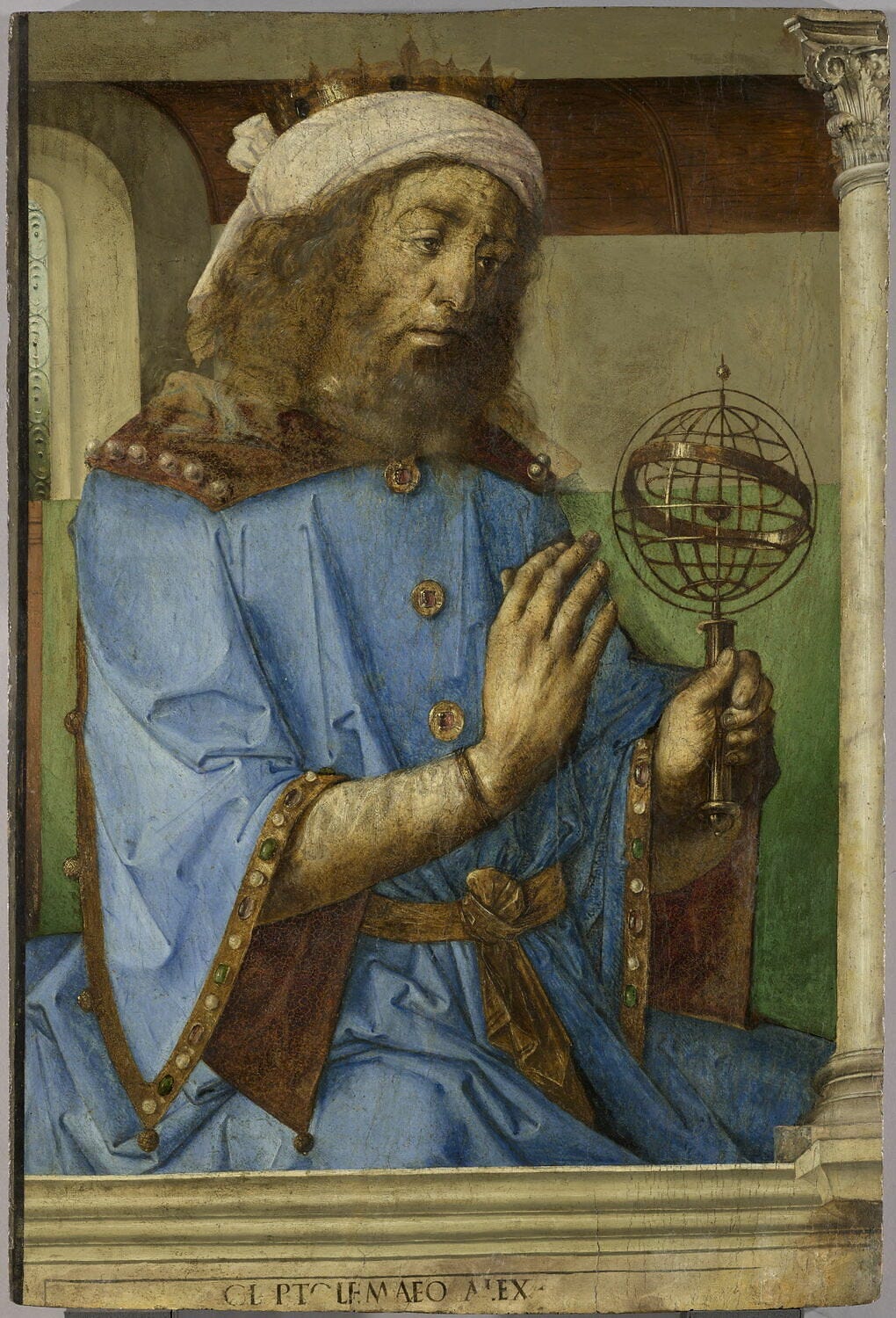
At primary school, our teacher told us about a person in ancient times called Ptolemy, who created early maps of the world. I found myself fascinated by this character, but not really for the right reasons. I quite liked his strange name which had that ‘silent p’ going on like ‘pterodactyl’ and I was intrigued by his weird map, wondering why it wasn’t like the world map on the classroom wall?
Much later, at university I gained a more coherent appreciation of Ptolemy’s significance. He seems to have pretty much invented this thing called geography in the second century. Around 140 AD he wrote the ‘Geography’ (Geōgraphikḕ Hyphḗgēsis in Ancient Greek which literally means ‘Geographical Guidance’) which focussed on maps, map making and significant places.
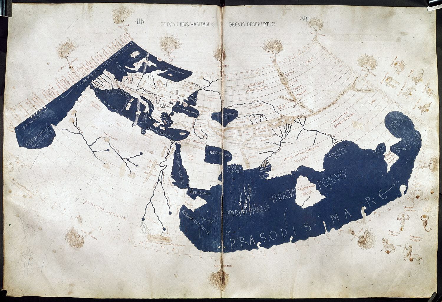
Ptolemy’s world map, reconstituted from Ptolemy’s Geography (circa 150) in the 15th century (Source)
The map I’d seen in primary school was Ptolemy’s oecumene or ecumene which meant the ‘inhabited world’ ‘known world’. His work was absolutely foundational for our ongoing journey of geographical enquiry. He was trying to make sense of geographical space, pioneering cartographical techniques and thus becoming a key ‘knowledge-maker’, inspiring others to become knowledge-makers. So that brief lesson about Ptolemy was a vital spark to my curiosity about the subject - it was my way in to the start of my geographical journey.
Since infancy, I’ve been travelling annually to Ireland to visit relatives and for holidays, but it wasn’t until this year that I found out about a connection with my Ptolemaic inspiration. I have often taken buses from the main bus station in Dublin called Busáras. Unbeknown to me until now is that underneath this classic modernist building is an abandoned theatre, The Eblana. It takes its name from ‘Eblana’ in Ptolemy’s ‘Geography’, where the city we now call Dublin made its very first appearance on any map.
What are the ancient roots of map apps?
What other impacts does Ptolemy have now? In October 2025, it was estimated that 5.78 billion or 70.1 percent of the world’s total population use a mobile phone. We don’t know exactly how many of these people use GIS map apps on their phones but it’s likely to be the majority.
All of these apps use digital gazetteers to support geographical enquiries e.g. Where’s that place I need to go to? How do I get from here to there? etc. This means that a routine geographical task which billions of people now undertake has its roots in Ptolemy’s work. After creating ‘Geography’, Ptolemy compiled an influential ‘Table of Noteworthy Cities’, a fragment of which survives known as the ‘Rylands Papyrus 522’. His list was by no means comprehensive of course, but it prompted questions that carry on to the present and into the future e.g. Why isn’t [placename] on the list? What’s that placename in a different language?
It’s very likely that when using such gazetteers we’ve struggled to find places e.g. looking for a house on a new estate; trying to find a place where the spelling varies or it’s written using characters in different alphabets. Ptolemy’s first list initiated a never-ending process of creating and updating what became known as gazetteers which quietly underpin all geographical enquiry by most people on the planet.
Are knowledge-makers on the curriculum?
It’s hard to put this delicately…compared to some other curriculum subjects, geography is extremely weak in celebrating its knowledge-makers. For example, I was recently chatting with biology colleagues about their approach to knowledge-makers. In a couple of minutes they converged on key characters that students shouldn’t leave school without knowing about: Darwin, Anning, Mendel, Watson, Crick, Franklin. Most of these names are actually recommended in the national curriculum programmes of study for science (DfE 2015).
I’m not sure that a gathering of geography teachers would be able to do that for their subject. More alarmingly, disciplinary knowledge is conspicuous by its absence from the national curriculum for geography. There is no reference to knowledge-making or knowledge-makers at all. This is surprising, because many geography teachers do actually bring knowledge-makers into their teaching, but such good practice is often undervalued and has yet to find approval or guidance in official curriculum documentation. This surely needs to change.
Why should we teach about knowledge-makers?
One very effective way to bridge the yawning disciplinary knowledge gap spotted by Ofsted is for students to learn not only about how knowledge is made but who made it.
There are very sound pedagogical reasons for doing this. Learning about the work of knowledge-makers inevitably develops a narrative linked to that person’s life and work. It provides students with a way in.
On starting a new case study recently, one of my students actually asked ‘are there going to be any people in it?’ This is because there were key characters in the previous case study which they had found memorable because they were able to build the wider narrative around them, to tell the wider story.
Educational research strongly supports the use of narrative. Daniel Willingham explains why narrative is so useful and powerful:
‘The human mind seems exquisitely tuned to understand and remember stories - so much so that psychologists sometimes refer to stories as “psychologically privileged,” meaning that they are treated differently in memory than other types of material.’ (Willingham 2009)
Professor Becky Allen echoes Willingham;
‘Students need a causal story they can reconstruct: a sequence of events that makes sense, connects to prior knowledge, and remains stable in memory. The features that make such a narrative stick, such as coherence, causation or vivid particular…’ (Allen 2026)
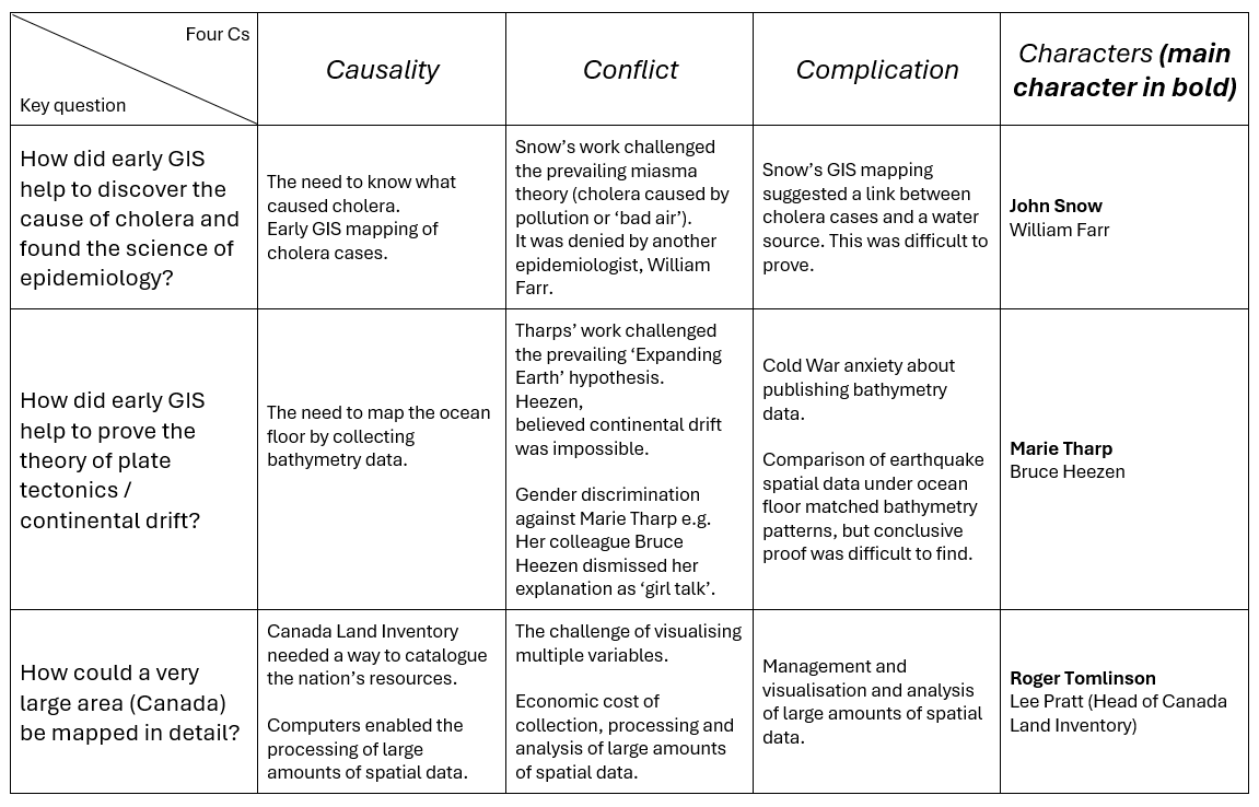
Stories make learning more memorable. Willingham suggests that narrative is typically characterised by ‘the four Cs’ of narrative: causality, conflict, complication and characters.
Who are the other knowledge-makers?
Apart from Ptolemy, which other characters might qualify as geographical knowledge-makers? There would be many contenders and considerable debate about who to include, but that would be a healthy step forward from the current vacuum.
Here are some suggestions, with apologies in advance that they all have strong links with GIS! But I would suggest that our students shouldn’t leave school without knowing about them:

Snow’s cholera map, showing pump and case locations (Source)
John Snow (1813-1858) innovated the georeferencing of data on maps to investigate the role of the water supply in a cholera epidemic in Soho, London in 1854. He is sometimes called ‘The Father of GIS’ and spatial epidemiology.
A topographical map of Marie Tharp and Bruce Heezen’s work, the first realistic depiction of complete ocean-floor bathymetry. Artist: Heinrich Berann. Used by permission of the estate of Marie Tharp Geography and Map Division.
Marie Tharp (1920-2006) mapped spatial bathymetry data about the ocean floor which provided a vital pathway to proving tectonic theory. Rather like Rosalind Franklin with the discovery of DNA, her contribution to geographical knowledge was not well-known until very late in her life (Snow 2026).
Roger Tomlinson (1933-2014) was the first person to establish computer mapping at scale using of digital layers to facilitate spatial analysis geographic data. He was the first person to use the term GIS by creating the Canada Geographic Information System (Cheshire 2017).
The table below summarises the way the narrative about these knowledge-makers might be structured following Willingham’s ‘four Cs’.
Shouldn’t leave school without knowing about…
Hopefully, as we reflect on ways to develop the geography curriculum, we can develop our teaching about disciplinary knowledge by celebrating some of the key knowledge-makers.
What do you think you’d add here? Who would you add to your list of key knowledge makers? Leave a comment and let us know!
Three key takeaway questions could be:
Who are the geographical knowledge-makers students shouldn’t leave school without knowing about?
What can we learn about geographical knowledge-making from the stories of these knowledge-makers?
What’s the best way to use narrative about knowledge-makers to make sure students remember how their work contributes to knowledge-making in geography?
Reading and References:
Allen, B. (2026) Engelmann Last: Why the hardest problems in education come before instruction begins.
Cheshire, J. (2017) Roger Tomlinson’s PhD: The first in GIS. James Cheshire blog. James Cheshire is Professor of Geographic Information and Cartography in the UCL Department of Geography and the inaugural director of the UCL Social Data Institute.
Conway, B. (2023) GIS in the Classroom: Why should we be using GIS in our lessons? Tutor2U
Department for Education (2015) Statutory guidance: National curriculum in England: science programmes of study.
Digital Around The World (2025) Global mobile adoption. DataReportal
Preece, D. (2026) Thinking like a Geographer: what are the big debates in (secondary) geography education? Learning to Teach Geography.
Ptolemy (c150) Geography (Ancient Greek: Γεωγραφικὴ Ὑφήγησις, Geōgraphikḕ Hyphḗgēsis, literally ‘Geographical Guidance’; Latin: ‘Geographia’,’Cosmographia) )
Ptolemy (c150) Table of Noteworthy Cities (Ancient Greek: κανὼν πόλεων ἐπισήμων, Romanised: Kanòn Póleon Episémon; also known as ‘the Kanon’)
Tomlinson, R. F. (1974) Geographical Information Systems, Spatial Data Analysis and Decision Making in Government. Doctoral thesis, University of London.
Snow, M. and Pastuch, C. (2026) Marie Tharp, the scientist who mapped the ocean floor. Library of Congress Magazine, March/April 2026.
Willingham, D. T. (2009) Why Don’t Students Like School?: A Cognitive Scientist Answers Questions About How the Mind Works and What It Means for the Classroom. Second edition (15 Jun 2021) Jossey-Bass/Wiley
Willingham, D. T. (2021) Ask the Cognitive Scientist: Why Do Students Remember Everything That’s on Television and Forget Everything I Say? American Educator, Summer 2021 via American Federation of Teachers (AFT)
About the author:
Brendan has led his geography department to the Geographical Association’s Centre of Excellence award twice. He has a wealth of experience in the use of Geographical Information Systems (GIS) in schools and supporting other schools e.g. CPD in GIS (including Digimap for Schools), ITT and ECF. He is a long-standing member of the Geographical Association Special Interest Group for ICT (GASIGICT). Brendan has authored many conventional and online resources (including Oak National Academy; Tutor2U; BBC Bitesize). He has consulted for and published through the Geographical Association and RGS and is a Fellow and Chartered Geographer (Teacher) of Royal Geographical Society.
Brendan shares resources and ideas regularly on Twitter, Bluesky, Linked In or via blogs such as Tutor2U, Internet Geography. Brendan is a keen atmosphere and landscape photographer, regularly sharing images via social media and BBC Weather Watchers and the Cloud Appreciation Society. Brendan has recently started to write GIS mapping apps for educational use which are being shared at Navigatio.
Haven’t seen Ptolemy’s map in a long time